Getting to La Souvigne
Comment arriver à la Souvigne
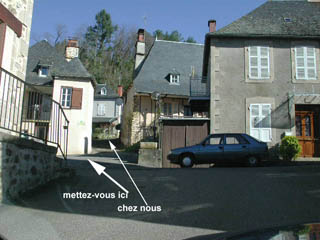
1 imp La Fontaine 19380 Forgès 05 55 28 63 99
Les rues de Forgès sont inconnues par les cartes GPS, utilisez ces co-ordonnées directement.The roads of Forgès aren't listed in the GPS maps, so program these co-ordinates directly.
GPS N 45°09’20"(45.15577) E 01°52’17"(1.87154)
- From the North - Du Nord - Paris Limoges
- From the East - De l'Est - Lyon Clemont-Ferrand
- From the West - De l'Ouest - Bordeaux Périgueux
- From the South East Du Sud-Est, Montpelier, Aurillac
- From the South West, Du Sud-Ouest, Toulouse Cahors
Directions from North
From Limoges Airport, take the exit, go straight on at the first roundabout, and follow the large blue signs to the Autoroute A20. If you set your trip meter on the exit road opposite the terminal, the sign directing you to turn left is only 600 metres away.
 200 metres further on you will
see the junction so turn LEFT and this takes you onto the
N520 (was D2000) clockwise.
200 metres further on you will
see the junction so turn LEFT and this takes you onto the
N520 (was D2000) clockwise. 
13 kms later you will come to two roundabouts in rapid succession, go straight over the first and turn right at the second towards Toulouse. You will be coming in at Jct 28.
En venant du Nord.
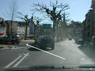
Pas d'instructions francophone de l'Aeroport de LimogesTake the A20 southbound (It's free from Vierzon to South of Brive). Leave it at junction 45 which is signposted Tulle, Aurillac & Clermont-Ferrand (Don't be tempted by the new A89 link, it's a snare and delusion unless you know the back doubles through Tulle). You will be on the D1120 (previously the N120). Carry on towards Tulle which is about 28 kms from the motorway exit. As you go down the hill into Tulle do NOT fork right towards "Centre ville", carry straight on (Toutes directions).
Empruntez l'Autoroute A20 (gratuit entre Vierzon et au Sud de Brive). Prenez la sortie #45 (signalisée Tulle, Aurillac & Clermont-Ferrand), et prenez D1120 (ancienne N120) direction Tulle (etc). Continuez jusqu'à Tulle - 28 kms après la sortie de l'Autoroute. En descendant, ne bifurquez pas vers la droite, direction "Centre Ville", mais continuez tout droit, "Toutes Directions".
Directions from East
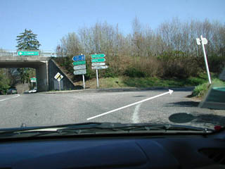
Take N89/A89 towards Tulle, Brive & Bordeaux.Do follow signs to A89 if you can as it makes a big difference to the journey. Take the Tulle Centre/Aurillac exit and join the N89 east of Tulle, don't be tempted to continue on A89 to Tulle Nord as it is useless for access to the south, where we are. Once on the N89, beware there is an automatic radar speed camera between the motorway exit and Tulle. From the N89 roundabout, carry on for around 10 kilometres and leave it at the second Tulle exit (signposted in Green - Aurillac - in white, Laguenne, Argentat & Mauriac). On descending the slip road, you will find yourself at a T junction on the D1120, turn LEFT (green signpost - Aurillac).En venant de l'Est
Prenez la A89, direction Tulle, Brive et Bordeaux. Prenez la sortie Tulle Centre/Aurillac, et empruntez le N89 direction Tulle. ATTENTION, il y a un poste Radar fixe après le rond-point. En arrivant à Tulle empruntez la deuxième sortie presque 11km après le rondpoint accès A89 (Tulle Sud - panneau vert Aurillac, et panneau blanc Laguenne, Argentat et Mauriac).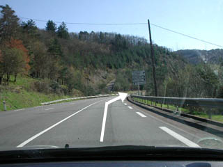
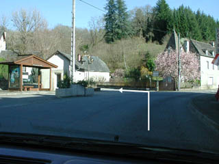
Ref A Repère A

Directions from West.
Take the A89 to junction 19 (Brive) following signs for centre ville and Tulle. After a longish slow one way section on little roads, you will pass a non roundabout at a bridge. Go straight on for a further km or two in the Tulle direction. Pass E Leclerc (good place for cheap petrol) and then at the roundabout in front of Géant, turn right. Cross the river and then at the next round about turn left. Carry on the end of the road, and turn right (mini roundabout). This road climbs a bit for about a km and arrives at a major roundabout (Rhin et Danube) on the old N121, now D921 where you turn left towards Lanteuil, Beynat & Argentat.En venant de l'Ouest.
Prenez l'A89 et emprunter la sortie #19 Brive. Suivre centre ville. Après une assez longue périple par des petites routes lentes en sens unique, vous arriverez au non rond-point au Pont Cardinal, allez tout droit direction Tulle. Continuez toujours au rondpoint devant Géant, où vous tournez à droit. Traverser la Corrèze et tout de suite après tournez à gauche au rondpoint. Continuer jusqu'au bout de la rue et au mini rondpoint tournez à droit. Cette route monte un peu et après environ 1 kg arrive au grand rondpoint "Rhin et Danube" sur le D921 (ancien N121) tournez à gauche direction Lanteuil, Beynat et Argentat.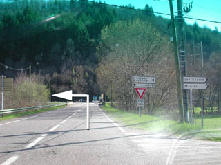
Directions from the South-East.
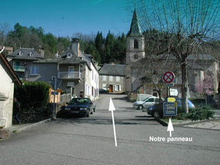
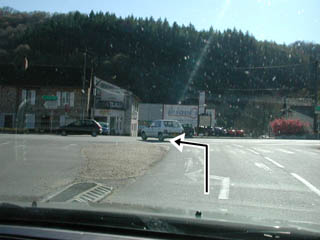
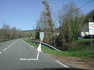
From Aurillac and the Cantal, take the D1120 (was the N120) in the direction of Tulle and Limoges About 5 kms after a long climb down the hill, you will come to the roundabout marking the start of the Argentat bypass, take it, following signs for Tulle etc. (not Centre Ville). After crossing the Dordogne, you'll come to another roundabout with the supermarket Casino on your left (a fair place to fill up your car during working hours). Go straight on towards Tulle. After about 10 kms you will see our roadside sign on the right Continue from ref BEn venant du Sud Est
Vous viendrez donc d'Aurillac et du Cantal. Prenez la D1120 (ancienne N120) direction Tulle et Limoges. A peu près 5 kms avant Argentat votre route fait une longue descente de 400 metres de dénivelisation et vous vous retrouverez à côté de la Maronne. Vous arriverez à un rondpoint, suivez Tulle etc, et PAS centre ville (à droite). Après avoir traversé la Dordogne, vous trouverez un autre rondpoint (primé nationalement pour son dessin) avec à gauche Casino (prix correctes pour faire le plein). Continuez tout droit, direction Tulle. 10 kms plus tart, après avoir traversé St Chamant, vous verrez notre panneau indicateur (normes européennes) Continuez du RepèreBDirections from the South-West
From Toulouse Cahors etc.Take the A20 northbound. Just after junction 52 for Beaulieu, Collonges, & Turenne at Noailles, beware, as there is an automatic radar speed camera. Leave at Junction 50 and follow instructions as from the West.En venant du Sud Ouest
De Toulouse, Cahors etc. Empruntez l'Autoroute A20 direction Paris etc. A la sortie # 50, au Nord de Brive, suivez les instructions ci-dessus en venant de l'Ouest.
Ref C Repère C